AscendXYZ
Radar Detection of Birds | Cutting Edge AscendXYZ Avian Radar Provider
AscendXYZ has extensive aviation industry knowledge developing disruptive solutions for the aviation industry. As an Avian Radar provider, AscendXYZ specializes in helping airports and airlines avoid expensive and potentially dangerous bird strikes by revolutionizing the way these are dealt with. Specifically, for wildlife monitoring AscendXYZ has developed a radar solution that records bird activity, makes real-time risk models, and creates activity predictions. AscendXYZ takes complex data sources and converts it into applicable, accessible, and actionable information used for airport safeguarding.
Imagine being able to predict bird activity to minimize the bird strike risk while at the same time having an overview of your airport area with real-time guidance for bird control staff, enabling a swift and effective response. AscendXYZ Avian Radar solution makes it all possible. Furthermore, it gives you access to automated reports and KPI’s that can be integrated smoothly into your wildlife risk management program with minimal work on your end.
– 24/7 Radar detection of birds – we offer you an easy to use end-to-end service that covers up to 150 km2.
– Real-time bird control guidance allows you to react in real time and take appropriate mitigative actions, making your airport an unattractive feeding area.
– Bird activity forecast enables you to plan appropriate mitigative actions and staff effort during high-risk periods without interrupting airport operations.
– Bird hot-spot identification pinpoints problem areas in and around the airport and helps you to take action to minimize future risks.
The AscendXYZ Avian Radar solution is an easy to use end-to-end service delivered to you in an intuitive interface together with automated reports that leave your hands free to take action.
We made it easy to get started. Since we are offering you a service, you can leave it to us to handle maintenance and insurance while you focus on the result. Tell us which service level you need, and we will help you identify the best location for the radar as well as deliver and install the system for you. All you need on your end is an external power source and internet connection. The user-friendly data will be available to you soon after, and you will be able to act on the results right away. User experience and usability of our solutions is the main focus for us. We are with you all the way – ready to help, guide, consult, and collaborate.
Besides the innovative radar detection of birds AscendXYZ offers digital wildlife registration, digital airport suite, obstacle assessment and management, and satellite monitoring solutions to simplify and support airport wildlife management.
AscendXYZ supports safe uninterrupted aircraft operations worldwide.
Company Profile
-
AscendXYZ Avian Radar
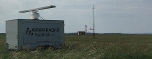
The AscendXYZ Avian Radar system is an end-to-end service, delivered as a mobile trailer solution that covers up to 150 km2. As soon as an external power source and internet connection are in place – the solution is operational. Our sophisticated algorithms enable automated segmentation and identification of birds. The results are presented in an understandable and accessible format in the AscendXYZ web-portal to the users at your airport.
Through a continuous identification and measurement of bird activity AscendXYZ Avian Radar solution offers you:
- Bird activity forecast, that enables you to plan appropriate mitigative actions and staff effort during high-risk periods without interrupting airport operations.
- Real-time bird control guidance: The AscendXYZ Avian Radar solution evaluates and relays bird activity to your bird control units in real time. The information enables bird controllers to see where and when birds enter the operations area. This allows them to quickly and efficiently disperse the birds, making the airport area unattractive for birds to feed.
- Area management: The solution gives you a clear and thorough overview of the bird activity in the airport operations area combined with runway crossing and near-miss analyses. This overview provides you with the foundation for a consistent evaluation of the airport area management plan.
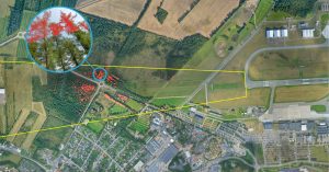
- Bird hot-spot identification: By analysing the historical radar data, bird activity hot spots and local migration routes can be identified, documented, and included in the risk assessment. As your bird activity hot spots are identified, the risk can be evaluated by performing on-site visits and by analysing the areas using the AscendXYZ 13 km satellite survey.
-
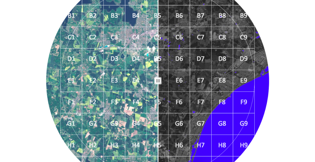
13 km Satellite survey
Imagine a 13 km survey that includes satellite monitoring, automated reports and a specialist assessment that can be used as a part of your wildlife risk management program.
With the Ascend 13 km satellite monitoring service, we will provide your airport with:- A complete 13 km survey;
- Landscape change identification;
- Off-airfield wildlife registration;
Your airport will frequently be mapped by the Sentinel-2 Earth observation satellite constellation, developed to perform terrestrial observations such as landscape changes. The satellite data will be made available to you.
The digital satellite maps let you, or our wildlife specialist, identify changes to the safeguarding zone, that impact wildlife behaviour. The 13 km monitoring module provides analysis and site registration capabilities, that allow you to act and mitigate the risk. With the Ascend solution, you get a complete overview of the 530 km2 safeguarding zone.
You will be receiving pdf reports comparing current and past satellite images. Maps are divided into grids, making it easy to locate relevant changes. You can view it both as a digital map, or by opening the “13 km report”. The reports should be signed and dated by you on the last page, and then saved as documentation.
-
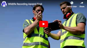
Wildlife Registration Solution
Wildlife registration used to be complex, time consuming and often missing important data. With the AscendXYZ Wildlife Registration Solution the process becomes quick, easy, and flexible. With our solution you can register wildlife with just a few touches on a tablet or smartphone – on site, with a direct view of the situation and minimal risk of forgetting or overlooking important points. This in turn offers you:
- Reduced risk
- Better documentation
- Peace of mind
- Time saving
The AscendXYZ Wildlife Registration Solution is an essential tool for understanding and mitigating the risk of wildlife strikes. The service is available as an App for mobile phone and tablet. The data is available for you right away, 24/7, in a digital format or as reports for management, specialists, and bird controllers. You can easily add new species, bird controllers, new tablets, wildlife risk levels and more to your reports through our web portal, allowing you to work flexibly and efficiently.
We will tailor the AscendXYZ Wildlife Registration app to match the needs of your airport, integrating the solution seamlessly into your existing safety management system and requiring no system changes or adjustments on your part. You will be ready to register wildlife activity right away.
-
Digital Airport solution
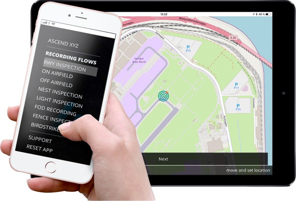
Any Process Can be Digitalized. No matter if you are performing a daily inspection of a fire truck or a runway inspection, we can digitalize the process in one easy to use solution. Imagine inputting all data capture processes with just a few touches of a tablet or phone. The AscendXYZ Digital Airport Solution makes this possible. With this solution, all gathered data is available for you right away in a real-time view, as well as in reports for management, specialists, and staff.
The processes we can digitalize for you with the AscendXYZ Digital Airport Solution include:
- Runway inspection
- Fence inspection
- FOD registration
- Equipment inspection
- Bird strike recording
- On-airfield wildlife registration
- Off-airfield wildlife registration
- Light inspection
- SNOWTAM
- Obstacle inspection
- and other specialized processes.
It is easy to get started – we will help you to set up the app, so you can be ready to record right away and follow the status in real-time. The service will be tailored to match the needs of your airport staff and processes.
-
Obstacle Identification, Management, and Assessment solution
Imagine being able to identify and manage all obstacles in your safeguarding zone, in one easy to use end-to-end service.
The Ascend Obstacle Identification, Management, and Assessment solution enables airports to identify and register obstacles, assess the impact on flight procedures, and publish obstacle data using one easy to use end-to-end service. Ascend uses LiDAR (Light Detection and Ranging) or satellite-based surface and terrain models to identify obstacles.
Products
AscendXYZ Avian Radar
AscendXYZ Wildlife registration