Augmented LiDAR© Software
| Company | Outsight |
|---|---|
| Product code | Version 5.5.0 |
Images


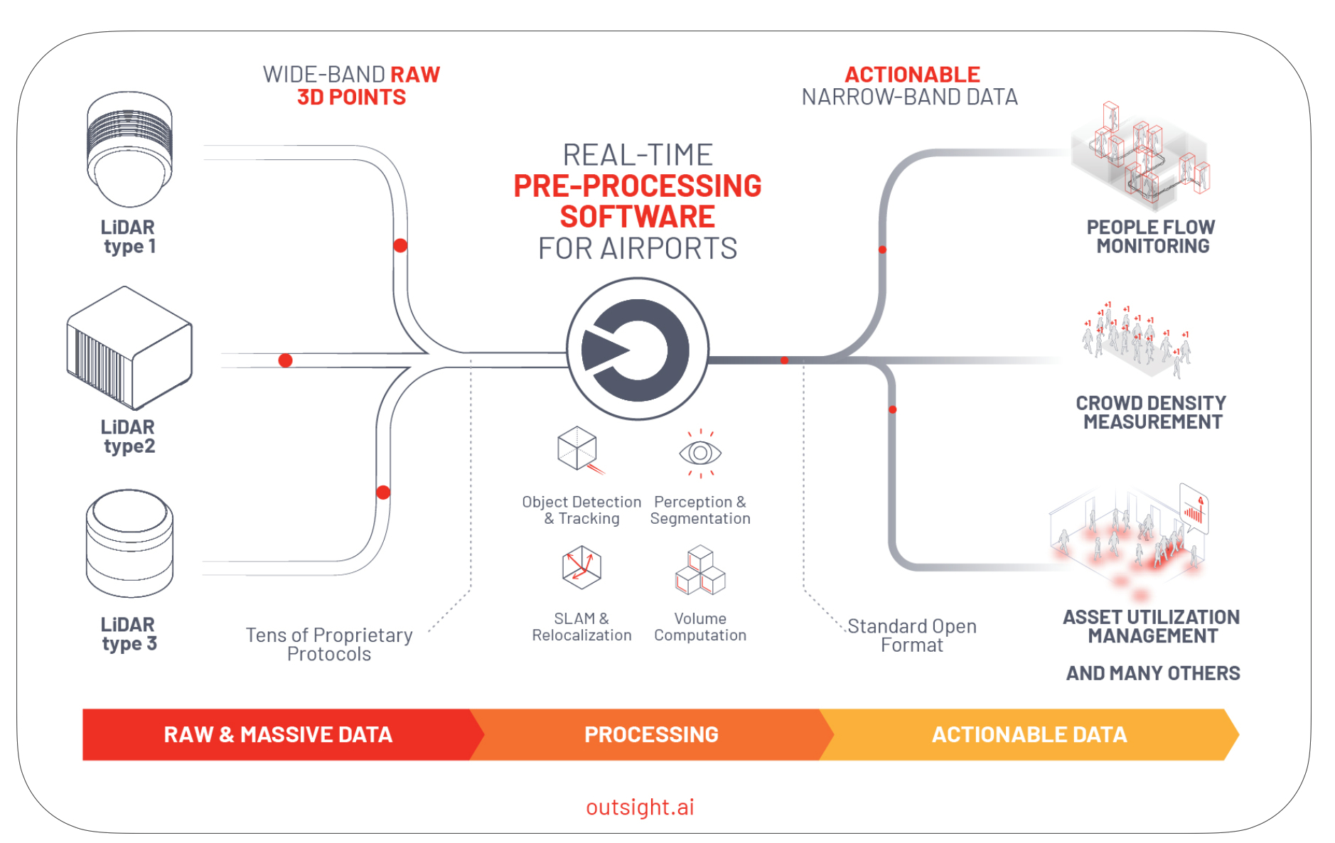
The Augmented LiDAR© Software is a real-time 3D LiDAR preprocessing software which is delivered in a ready to use box for convenience and a seamless integration experience.
The purpose of the Augmented LiDAR© processing unit is to deliver an actionable stream of data for applications requiring real-time Spatial Intelligence in dynamic environments, such as airports.
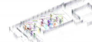
Augmented LiDAR Software
For the biggest airport groups worldwide, Outsight used the Augmented LiDAR© Software to generate actionable information (in the form of a real-time dashboard) and manage the flow and density of objects and people in several airport functionalities, including passport control, baggage tracking and delivery, check-in queues, social distancing for covid-19 testing. You may refer to the videos in this page to find out more.
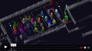
Augmented LiDAR Software for Airports
The main input of these applications is point-cloud data from a LiDAR device providing at least range and intensity information. Optional IMU can be used if it is natively available as an embedded feature in your particular LiDAR model.
The output of the Augmented LiDAR© box is organised in 5 different processing layers:
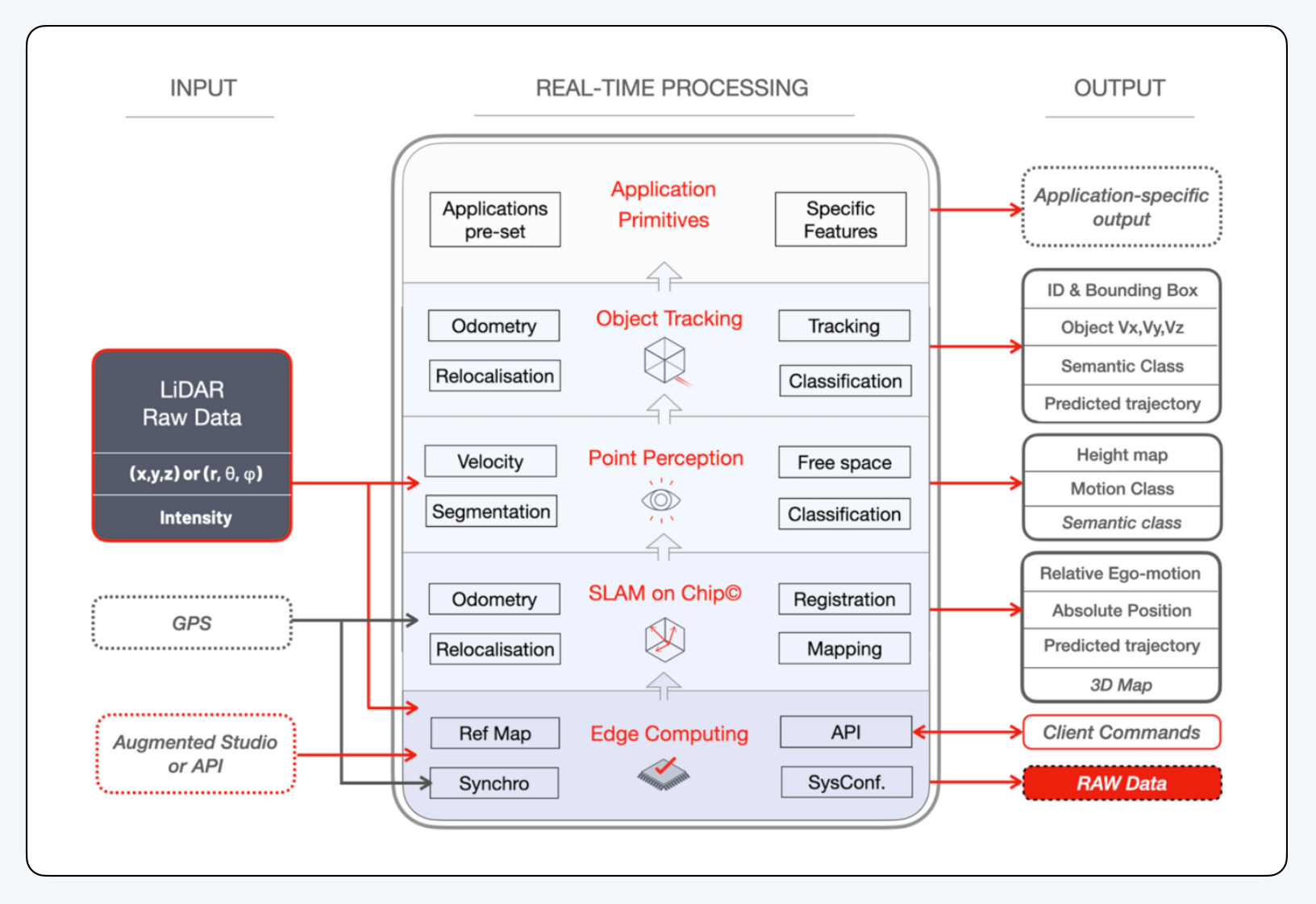
Features Stack
- Edge computing (performing system configuration and control),
- SLAM on Chip© (localisation & mapping),
- Point-wise Perception (providing raw enriched data)
- Object tracking (object-level data).
- Application primitives (out-of-the-box features that simplify high-level applications).
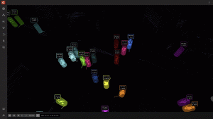
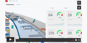
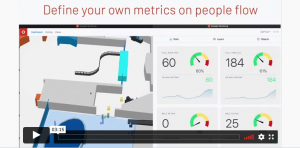
The final output application for airports is a Spatial Intelligence Platform, a live dashboard, where one can follow real-time aggregated KPIs as well as observe and track moving objects in different airport areas.
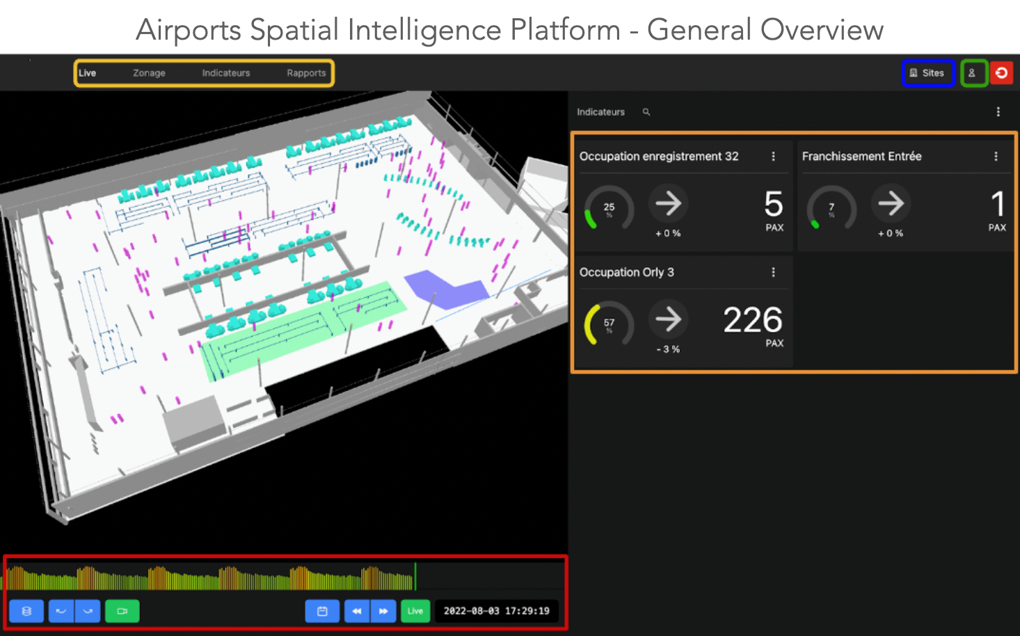
Airport Spatial Intelligence Platform
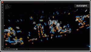
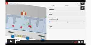
Additionally, the customer can set up the map’s view in several modes (2D, 3D, Patrol Zone), construct zones of interest (to track KPIs in a particular area of the airport), manage/customize KPIs to meet various demands, and generate reports (to be shared with other members of the team).
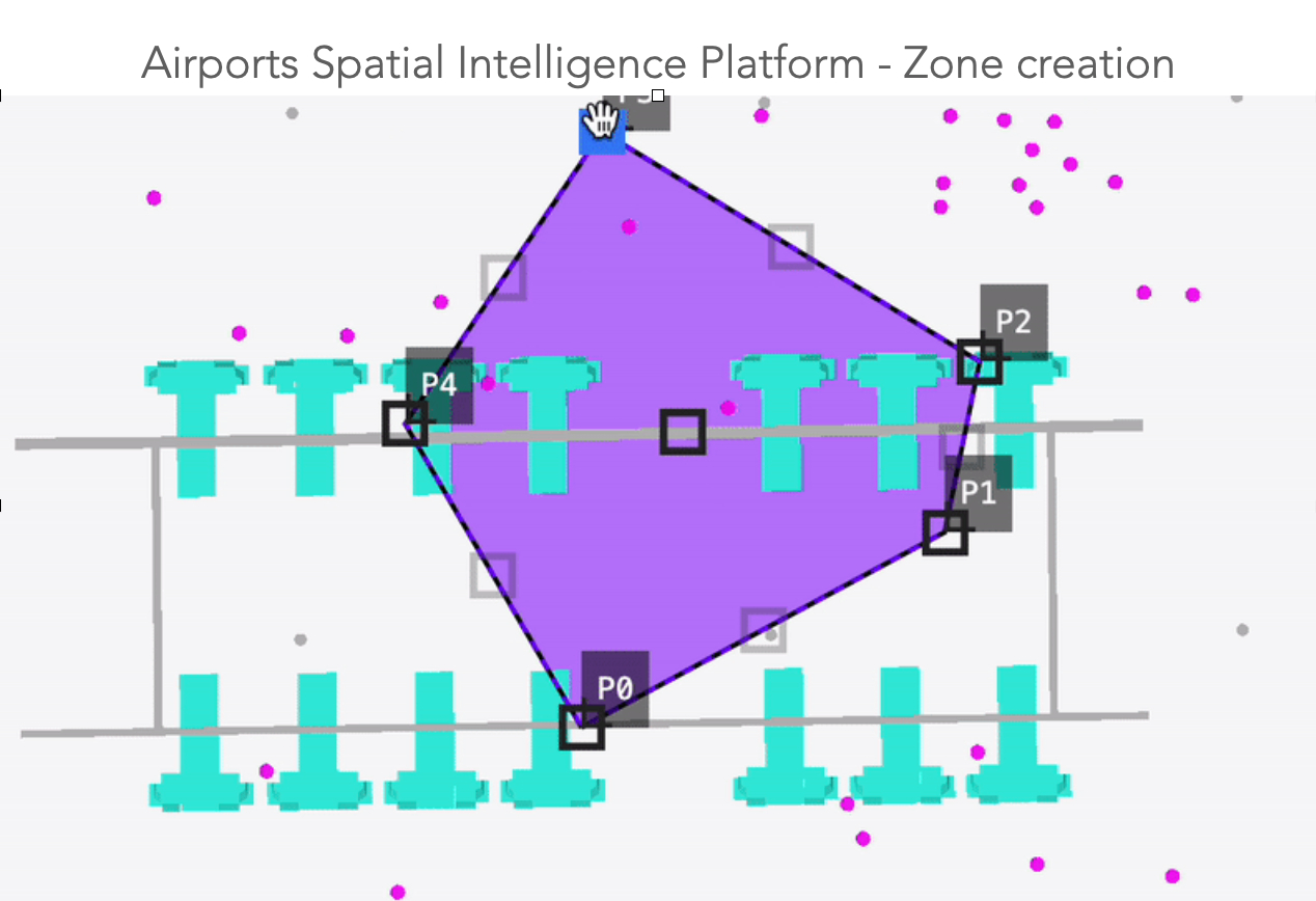
Airport Spatial Intelligence Platform Zone Creation
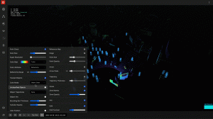
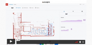
Outsight software enables increased operational awareness and efficiency by giving operators of major facilities real-time insights about people flow and asset use.
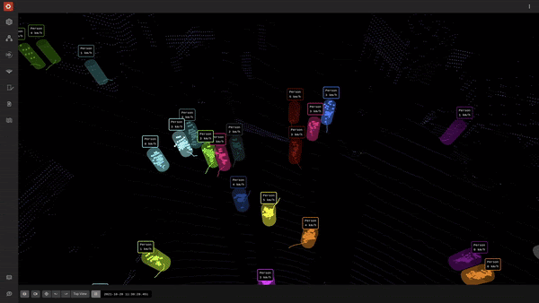
These insights are possible at a scale and level of detail never before possible thanks to LiDAR and the exceptional performance of Outsight’s software solutions: tens of thousands of simultaneous objects and travellers can be tracked with a precision of a few centimetres across large areas, such as several Terminals.
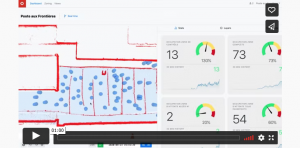
Airport Spatial Intelligence Platform Tracking in large areas
Here are some requirements met by Outsight’s Augmented LiDAR© Software to achieve operational excellence in Spatial Intelligence solutions:
- Ability to monitor wide areas of many square metres, at different levels, from Parking to Departures and Arrivals
- Ability to extract instantaneous and aggregatable KPI data, where the right KPIs can be set by the users, easily accessible from any web browser.
- Ability to be scalable and future-proof, since employing, integrating, and combining various sensors from different manufacturers is essential for both immediate and long-term success.
- Ability to manage the whole project lifecycle. As the project evolves and the solution becomes increasingly interconnected to other airport systems, only open API solutions with standard protocols can guarantee the required flexibility.
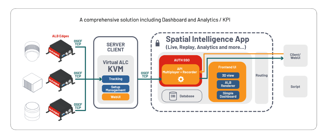
Comprehensive Solution
For more information about our product, download our Whitepaper here.
Connectors:
- LiDAR: High density DSUB 15 pins, DE15 male – Data transfer and LiDAR power
- Ethernet: M12x1 X coded industrial ethernet connector female – Data Transfer to host PC
- GPS input: Shielded connector M8x1 type, 6 pins, female contacts – Optional GPS location info
- LED: Status LED – User information
- Power: M12x1 T coded – Power for ALB and LiDAR
Mechanical:
- Dimensions with mounting pads and connectors: 59.3mm (H) x 135.5mm (W) x 137.2mm (L)
- Dimensions without mounting pads: 49mm (H) x 108.6mm (W) x 118mm (L)
- Weight: 690g
Electrical:
- ALB Power supply voltage: Min-Max 8-32V
- Power consumption – LiDAR power not included: Max 15W
- LiDAR power supply output (12V setting): Min-Max Voltage 11.5-12.5V / Max current 4A
- LiDAR power supply output (24V setting): Min-Max Voltage 23-25V / Max current 2A
Operational:
- Ingress protection: IP65 when appropriate cables are connected or with waterproof connectors caps.
- Operating temperature range: -40oC to +70oC (case) , -40oC to +50oC (ambient)
- Storage Temperature: -40oC to +85oC
- Electrical Safety: IEC/EN 62368-1:2014
- Shock / Vibration:
- IEC 60068-2-27:2008
- 50 g, 11 ms, +- 3 unique impacts / axis
- 25 g, 6 ms, +- 1000 impacts / axis
- 50 g, 3 ms, +- 5000 impacts / axis
- IEC 60068-2-6:2007 and IEC 60068-2-64:2008
- 10 Hz..1000Hz
- 10 Hz..500Hz, 5g, 20 frequency cycles
- 10 Hz..250 Hz, 4.42 g RMS, 5h
- EMI / EMC:
- IEC/EN 55032: 2012/AC: 2013, Class A
- IEC/EN 55024:2010
- FCC 47Cfr Part 15B, Class A
- Certifications: FCC, RoHS, CE
Accessories:
- Cable + Power Supply Unit: M12x1 T coded- cable 1,5m- 18V 60W class 2 power supply
- ALB- LiDAR interface box Y cable: D-SUB 15P FEMALE 2- 1.5m long cable- RJ 45 8P8C MALE and DC Plug 5.5*2.1
- Ethernet Cable: M12 8P Plug, cable TPU Flx Inline to RJ45, 2m long